|
I knew that Rod Meldrum was not the father of
the Heartland Model, but only recently did I learn of the lesser role that
Wayne May played in the birth of the touted geography. Certainly, Wayne nurtured the
Heartland Model. He tried to
revise and adjust
it. He ardently promotes it, and has prospered by it. But is it
essentially his brain child, or someone else's Caliban?
On the spine of Volume One of the THIS LAND
series, you will find the name
Edwin G. Goble followed by Wayne N. May. Subsequent volumes of the
series carry only Wayne's name as author, or editor.
Who is
Ed Goble?
Ed is an LDS Scholar perhaps best appreciated online for his unrelenting defense of the
Book of Abraham.
I recently copied Ed on an email to a valued colleague. In the email I suggested that
Wayne May should be credited with the Heartland Model. This brought a loaded
response from Ed. Ed filled us in on little known details about the origin of the
would be Book of Mormon geography. "I claim not that I am the sole
inventor", said Ed up front, "but sort of the originator of the basics
of the one [early version of the Heartland Model] that sort of “made sense” ... a
model that sort of “worked” ... Wayne May didn't particularly
care about the geography that much [at the time] ... and I didn't care about
his ... tablets [bogus
Michigan relics etc.]"
To understand how the nascent Heartland Model came
together, or rather how Ed pieced it together, we need to review its key
geographic elements:
CUMORAH in NY
"I always
believed Cumorah was in New York", Ed began, "but couldn't make the rest work in the
early days."
When Ed mentions "Cumorah" he means the Book of Mormon "hill Cumorah".
Ed accepts the tradition that the large drumlin hill from which Joseph
Smith retrieved the golden plates containing the
Book of Mormon, is one and the same as "the hill Cumorah" of
scripture. LDS Scripture does not actually say this. Scripture does clearly
point out that "the hill Cumorah" is in "the land Cumorah".
(Mormon 6:4-5, see also
1837 Edition) We are given the general whereabouts of the land Cumorah
in LDS Scripture. (LDS Doctrine and Covenant 128:20)
The Hill Cumorah tradition
goes back
to Joseph Smith's associate Oliver Cowdery. The strongest supporting
evidence for the tradition comes from the fact that Oliver's identification
of the "hill Cumorah" was
included in Joseph Smith's history.
(J.S. Papers, History 1834-1836, pg. 86)
Second hand accounts quote both Joseph and
the angel Moroni as referring to the same large drumlin hill in Manchester as "hill of Cumorah", meaning
hill of the Book of Mormon land Cumorah. But whether the traditional Hill Cumorah is one and the same as "the hill Cumorah"
of scripture, or just one of several hills in the land Cumorah,
is not known for certain. In any event, the traditional Hill Cumorah is the most authoritatively established site on the
Heartland setting map.
LDS Scripture, signed by Joseph Smith, definitely places
"Cumorah" (the land) near the Finger Lakes of western New York.
The Smith family log home, where the angel Moroni appeared to the young
prophet, and declared "the fulfilment of the prophets, the book to be revealed"
was in Cumorah, the Book of Mormon land.
(LDS Doctrine and Covenant 128:20)
MANTI in MO
When Ed says that apart from Cumorah, he "couldn't make the rest work
...", the nature of his geographic problem needs to be appreciated. Ed
was trying to satisfy more than the best sources. He was relying on more
than LDS Scripture and verifiable statements by the Prophet Joseph
Smith. Ed was trying to reconcile statements published by other prominent
Church leaders; e.g. Joseph Fielding Smith, Doctrines of Salvation,
edited by Bruce R. McConkie [Salt Lake City: Bookcraft, 1954-1956],
3:239.
Church authorities unjustifiably attributed to Joseph Smith a geographic tidbit
that Ed became obsessed with. "Yes, I was taken with Manti in Missouri
because of the reports from Church authorities", says Ed. So
Manti in MO became the next
essential piece of the nascent Heartland geography. Conflict surrounding the
Missouri Manti is also at the heart of why Ed finally rejected his
geographic creation - but we'll get
to that shortly.
The Book of Mormon Manti is a land and city situated in the southern
highlands of Nephite territory, near the head
(source) of the
river Sidon.
(Alma 16:6;
22:27,
29;
43:22)
The great earth and timber city Zarahemla was
less than a day's march northward,
downhill from Manti.
(Alma 56:13-15,
25;
58:13,
23-27)
Manti was not far from the Book of Mormon's east and west seas.
(Alma 53:8,
22;
56:13-14,
31;
58:13-14;
59:5-8;
51:25-26)
The earliest available source of the Manti in MO claim comes from an 1838
journal entry by Samuel D. Tyler. Brother Tyler did not specifically
attribute the Manti in MO idea to Joseph Smith.
This leap was made by
Church authorities years later.
Adding to the confusion, Elder Joseph Fielding Smith taught that Book
of Mormon civilization "was principally ... in the south [Central and
South America] and not in the region now comprising the United States." (DS 3:73-74) His
statement contradicts the placing of Book of Mormon Manti on U. S. soil. But LDS Scripture challenges Elder Smith's generalization.
(1 Nephi 13:30,
2 Nephi 10:10-14,
1 Nephi 13:13,
15,
20,
Ether 2:7-12,
LDS Doctrine and Covenant 10:49-51; consider also
3 Nephi 20;22,
Ether 13:6,
LDS Doctrine and Covenant 28:9;
42:9,
35,
62;
45:64-71;
84:2-3)
By tradition, Elder Smith accepted a far-flung Hemispheric Model similar to
the one that Elder Orson Pratt inserted in the footnotes of the 1879 Edition of the Book of Mormon.
Elder Smith stated, "It is generally understood that they [family of Lehi]
landed in South America ..." (DS
3:73-74)
ZARAHEMLA in IA
"There was a guy named Duane Erickson that “sort of” affiliated with Wayne May ... This guy placed Cumorah in New York and Zarahemla in Iowa
across from Nauvoo (i.e. from a misreading of D&C 125) ... his Sidon was the
Mississippi." Ed continued, "... the Heartland
Theory only preserved a few ideas from him. I realized that Erickson's idea
of Zarahemla in Iowa worked with Manti in Missouri, and that the
Mississippi seemed like a good candidate [for Sidon]."
Try crossing
that on foot like Sidon!
In hind sight, Ed is clear on the fact that
LDS Doctrine and Covenant 125:3
does not actually say that Zarahemla of the Book of Mormon
was in Iowa. It was because the Iowa Zarahemla seemed to fit with Manti in MO, that Ed "was pretty convinced back then about that."
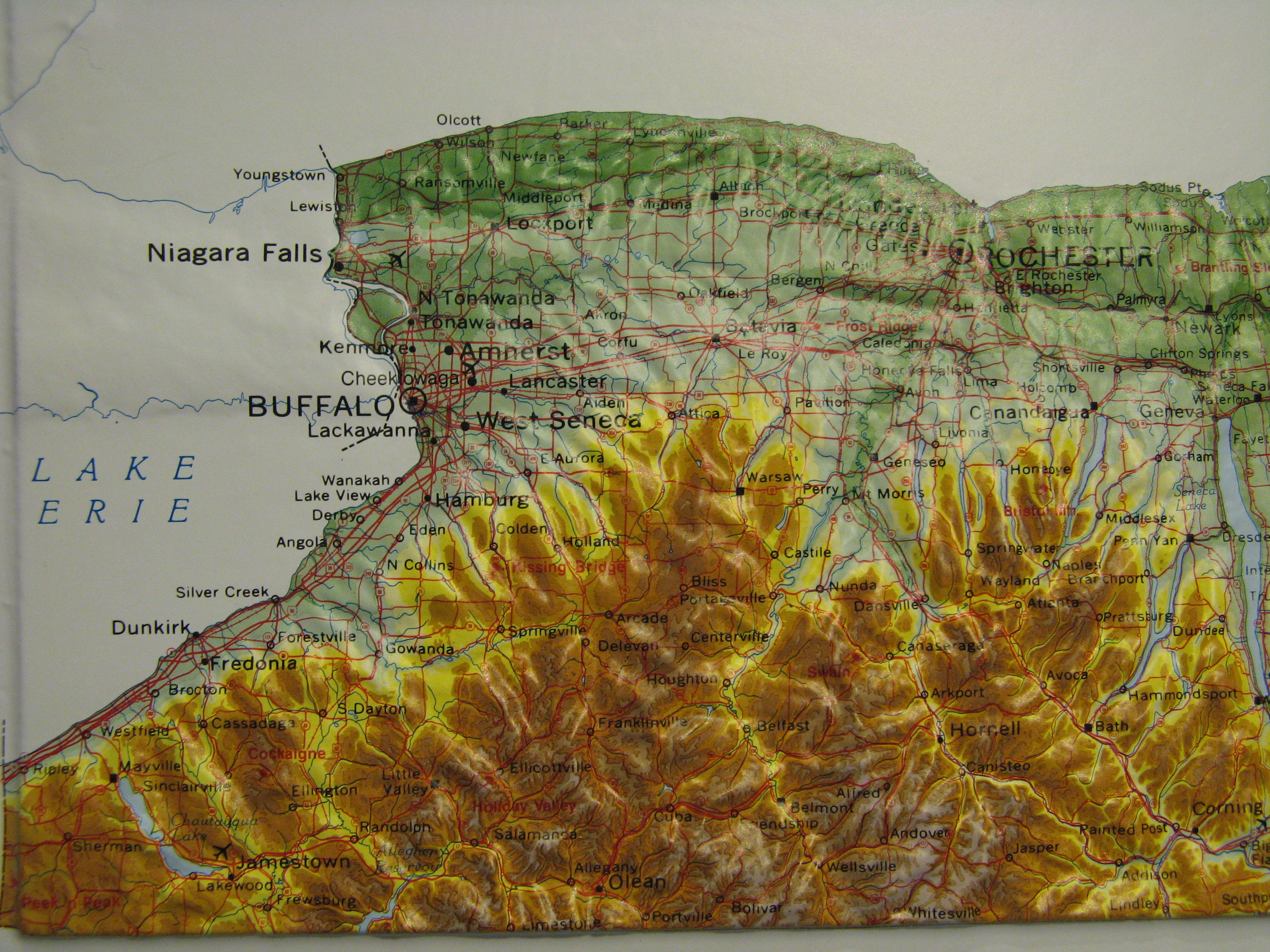
NARROW NECK (NIAGARA ISTHMUS)
Ed recounts the evolution of the early Heartland Model's narrow neck of land idea: "I couldn't figure out a good candidate for the Narrow Neck of Land. I
settled on the idea of a coastal corridor along Lake Erie for my "narrow
neck" following the "coastal corridor" hypothesis of David Hauk (who is a
Mesoamericanist that rejects the isthmus [Tehuantepec]
theory). So this early theory was sort of starting to work".
Ed was open to adapting Mesoamerican setting ideas to his model to prop up its
plausibility in the eyes of respected associates.
But the Heartland narrow neck idea continued to evolve. Ed goes on to explain: "There was this guy named Duane Aston and another guy named Delbert
Curtis [Delbert W. Curtis, The LAND of THE NEPHITES, Copyright 1988]. Both believed that the neck of land was Niagara. I still didn't
buy that at that early period. But when I found from Indian place name
dictionaries that Niagara in Iroquoian means “neck” or “point of land cut in
two”, this won me over." (Ed cites Rydjord, John Stewart, 1968,
Indian Place-Names, Norman, University of Oklahoma Press, pp.
267-268; George R., 1970, American Place Names, New York: Oxford
University Press, p. 327)
Ed's findings on the possible meanings of Niagara
could be significant! Had he let go of the unscriptural sites, and kept things closer to Cumorah,
his model may have turned out much more compact, like one of
Phyllis Olive's early models, with,
perhaps, at least one important distinction: The Book of
Mormon "narrow neck" is probably distinct from "the narrow pass";
both of which situate near the
Desolation-Bountiful line.
It makes abundant sense that this important geographic line, the Desolation-Bountiful line, follows the
Onondaga Limestone Escarpment
in western NY. As described in scripture, the land
Bountiful situates "up", south of the escarpment, while the land of
Desolation resides at lower elevation on the north.
(Alma 22:30-31)
Modern roads run parallel to the linear limestone formation.
Ed (or someone else) could have realized that
reference to "a great city by the narrow neck of land, by the place where
the sea divides the land"
(Ether 10:20)
precisely describes the site now occupied by modern Buffalo NY (formerly New Amsterdam).
A study of the book of Ether shows that it is consistent to place Cumorah eastward from Moron (near the land of Desolation), and
therefore eastward from both
the
narrow neck of land (Niagara Isthmus,
Ether 10:20;
7:6;
9:3;
14:6,
26;
15:8-11), and the narrow pass
(Batavia Moraine,
Alma 50:35).
Apply
Israelite coordinates
(East is towards sunrise) and it becomes apparent that "curious" (meaning
"ingenious",
חשב) Hagoth launched his "exceedingly large ship" into Lake Erie,
"the west sea, by the narrow neck of land which led into the land northward".
(Alma 63:5)
He built his great ship "on the borders of the land Bountiful, by the
land Desolation ..." Today, two battleships and a refitted WWII submarine are
moored near this site - near the mouth of
Sidon (Buffalo River).

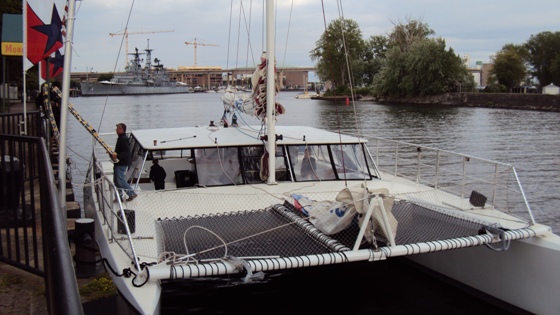
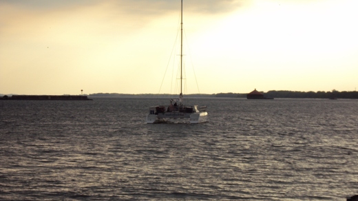
A large catamaran launches out into the "west sea" (Lake Erie)
from the mouth of "Sidon" (Buffalo River) -
by the divided Niagara Isthmus.
(Alma 63:5)
So west in the Near Cumorah setting, is both seaward and in the direction of the setting sun,
just as on the Mediterranean coast of Israel. Take into account
ancient
Lake Wainfleet, now reduced to
wetlands on the Niagara Isthmus, and we may consider that the narrow
neck of land needn't have included the entire divided isthmus; but could have been a smaller
isthmus on the
Onondaga Escarpment, just across Niagara
from
Buffalo. Unlike the narrow pass (Batavia Moraine,
Mormon 2:29),
scripture does not say that the divided isthmus called "the
narrow neck" led
into the land southward, only into the land northward.
(Alma 63:5)
Divided Niagara Isthmus,
southward rise in elevation,
northward flowing rivers, and
northern plains.
An Eclectic Geography Emerges
Ed describes piecing together his creation: "so, I
combined my Manti in Missouri obsession with the Niagara neck and the
Mississippi Sidon, with Erickson's idea of Zarahemla in Iowa - all together in
one theory. This was the nascent Heartland Theory. This finally materialized
in about 1997 or 1998 - when I finally got all of this together in one."
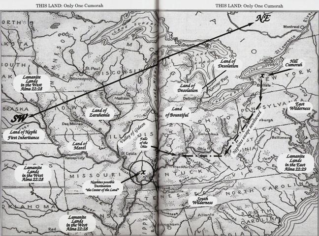
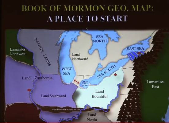
Here is a Map of the nascent Heartland Model found on page 75 of Volume One
of the THIS LAND series. The book carries a 2002 copyright by Edwin G. Goble
and Wayne N. May.
Why isn't the Book of Mormon land of Desolation
marked on
the map above? Desolation should be north of Bountiful, which is north of Zarahemla,
which is north of Manti, which is north of the land of Nephi.
Ed explains: "My idea of Desolation was the heartland of an ancient culture dating to the time of the Jaredites that was up
[Ed means north; Desolation was at lower elevation compared to Bountiful, Alma 22:31] in Ontario. At that time, I was heavily influenced by Mesoamericanist
thinking, focusing on “Spheres of Influence” of ancient cultures, as well as
“heartland” areas of cultures. So, I focused in on archaeological heartland
areas even though I didn't have good evidence of cities. ..."
Notice that Ed placed
the Jaredite land of Moron (4), which according to scripture was "near the
land which is called Desolation by the Nephites"
(Ether 7:6), north in
Canada. But wait, didn't Moron, the seat of Jaredite power and inheritance, reside in a land
that prophetically would become "free ... from all other nations under
heaven"? (Ether 2:12)
That's not Canada.
Jaredites, no doubt, migrated into Cananda, but their inheritance and seat of power was near Desolation, on what is now United States soil.
(Alma 46:17)
Ed's model tries to accommodate the existence of scriptural seas on the west
and east of Bountiful (also flanking more southern lands) by applying a Mesoamericanist
handwave
argument - skew the directions! This argument is foisted by BYU
luminaries like John L. Sorenson. "I was influenced by the Mesoamericanist thinking on the
Nephite North thing" says Ed, "it was convenient to explain skewed
directions." So Ed has on the map, all the Great Lakes combined as
the "Sea West" (2). From "the waters of Ripliancum"
(Lake Iroquois/Ontario, Ether 15:8,
1879 LDS Edition of the Book of Mormon) to
Hiawatha's
"Gitche Gumee"
(Lake Superior), the Heartland Model considers all these the "Sea West" (2, 2, 2, 2, 2).
Actually, "west sea" is a proper noun in translated scripture.
(Zechariah 14:8) The
relative expression "sea west" simply means
sea on the
west - whatever its name (e.g. Helaman 3:8,
as also "sea southward",
Joshua 18:14;
as also "sea east" or "sea ... eastward",
Alma 22:27,
Numbers 34:11
etc.)
According to the Book of Mormon, Lehi's company crossed "the large waters
into the promised land", to finally
arrive near the west sea. (Alma 22:28)
It was from this freshwater west sea that Book of Mormon people spread after a
famine. (Helaman 11:17-20)
The nascent Heartland Model, however, has Lehi landing on a coast of
the Gulf of Mexico (10).
Noting the general location of the land Bountiful (11), one is left
to wonder where exactly is the Desolation - Bountiful line that ran "from the east to
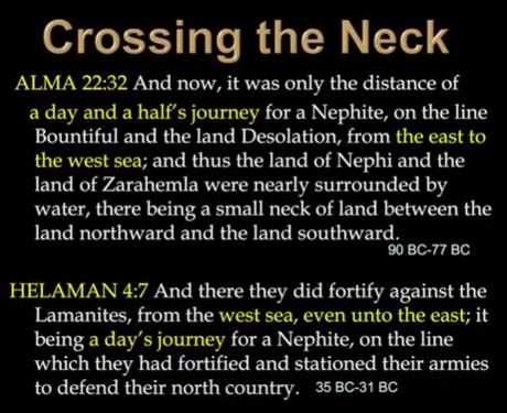
the west sea"? According to Alma 22:32
this line could be journeyed on foot in only
1.5 days (periods of daylight).
Where is the "narrow strip of wilderness, which ran from the sea east even to the sea west",
same as the "straight course" of the land of Nephi, which formed "the line between … the land of Zarahemla
and the land of Nephi", running from
"the east sea to the west [sea]" -
where is it on the Heartland Model map?
(Alma 22:27;
50:8-11)
The "narrow
strip of wilderness" is not the same as the more northern "small neck
of land", or "narrow pass".
(Alma 22:32;
50:34)
Don't confuse the two. The authors of the
October 1, 1842 ZARAHEMLA piece
(published in the Times and Seasons newspaper)
thought,
at the time, that the
Panamanian Isthmus of Darien could be "the
small neck of land" with "Zarahemla" in Central America. These brethren eventually came to understand that "the small neck of land" was
north, not south of Zarahemla. They eventually changed
their opinion about Zarahemla's location. They chose South America (1879 Edition).
Why didn't this constitute a betrayal
of Joseph's opinion? It's because Joseph Smith didn't write the
unsigned T&S ZARAHEMLA piece,
positing Zarahemla in Central America.
The ZARAHEMLA piece is very likely the work of John Taylor and
Wilford Woodruff.
(See Roper, Matthew, "Limited Geography and the Book of Mormon: Historical Antecedents and Early Interpretations", FARMS Review, 2004,
wherein
Roper attributed the unsigned ZARAHEMLA piece to Apostle John Taylor, Acting Editor of the T&S) It should be noted that
John Taylor's published articles
on Stephens' and Catherwood's discoveries in Central America, never
mention the Isthmus of Tehuantepec. They mention the "Isthmus of Darien"
at Panama.
If Ed's Heartland geography were correct, then Limhi's search
party sent out from the land of Nephi (8) on a mission to find Zarahemla
(5), got lost in the wilderness, ended up in a land of "many waters"
in the vicinity of Cumorah (3), where the Jaredites were destroyed, and there thought they had
come upon "the land of Zarahemla" (5).
(Mosiah 8:7-8;
21:25-26)
Did you catch that? The search party would have had to think they were in
Iowa when presumably they had arrived in upstate NY - if the Heartland
Model were true. If you think that
scenario is absurd, imagine Zarahemla, and the land of Nephi in
Central or South America. By the way, the "land of many waters"
(Mormon 6:4-6)
associated with Cumorah
and the hill Ramah, is referenced as "southward" from the "waters of Ripliancum"
(Lake Iroquois/Ontario,
Ether 15:8-13,
1879 Edition).
But by Ed's Mesoamericanist
styled screwed directions, we are required to think of this as
"eastward" from "Sea West" (2).
Though Ed's model certainly stretches distances described
in the American scripture to the point of incredulity, and though he
reorients cardinal directions by about 45 degrees, it needs to be
stressed that the Heartland Model's exaggeration, and twisted compass is the result of trying to
accommodate unscriptural sites.
All things considered, Ed
did the best possible job he could to try and reconcile things scriptural, with
unscriptural geographic tradition (Manti in MO).
Ed gave it his best shot! In so doing, Ed wasn't just thinking two
dimensionally. He was actually trying to place the land of Nephi at
higher elevation than the land of Zarahemla. Scripture consistently
describes this difference in elevation using the prepositions "up" and
"down". That is why
Ed placed the land of Nephi
(8) in the Ozarks.
But according to scripture, Manti was also at higher elevation than Zarahemla.
(Alma 16:6;
56:13-15,
25)
On the ground
"Manti" in MO (Huntsville, 804 ft) is not noticeably higher than Zarahemla IA
(~670 ft), considering the hundred mile or so distance between them.
DESOLATION in IL Bodes Ill!
Look again at where the lands of Manti (6), Zarahemla (5), and Bountiful (11)
situate on
the Heartland Model map above. Now imagine the heartburn of trying to fit
the northern Book of Mormon land of
Desolation in the prairies of Illinois!
"In 2002 I became kind of aware of the statement in the Levi Hancock journal
stating that the land of desolation extended up [northward from Central
America, in Ed's mind] into Illinois, which started
to cause cracks in my faith in the nascent heartland theory. I tried with
all my might to explain away the statement, trying to say that it didn't
mean what it said. Finally, I admitted to myself that this was not
intellectually honest, and I finally publically retracted the heartland
theory in about 2004 ..."
Ed experienced what happens when one
relies on sources other than the best, to layout the Book of
Mormon's covenant lands. Ed was right to recognize Levi Hancock's
secondhand (perhaps third-hand) account of what Joseph Smith supposedly said
to Sylvester Smith, as more authoritative than the Manti in MO claim. But
Levi Hancock's journal entry
is not authoritative enough! Sure, its more authoritative than Manti in MO,
because Brother Hancock actually alleges that Joseph Smith said such and such, to so and so about the land of desolation that king Onedages
(sounds like Onondaga) ruled over. The problem
is, we can't confirm firsthand what Joseph actually said to Sylvester Smith,
and in what context. The earliest available source of the Manti in MO claim,
by comparison,
doesn't mention Joseph Smith at all. Both these sources (Samuel Tyler, Levi Hancock) should be set aside
when it comes to placing the principal lands of the Book of Mormon.
It should be noted here, that Ed continues to see
Levi Hancock's journal entry
as an authoritative statement. He interprets the journal entry as proof that
Joseph Smith taught that the prairies of Illinois coincide with the Book of Mormon
land of Desolation.
Over the years, a lot of Church authorities have claimed, without
substantiation, that Joseph Smith said this or that.
Take for example First Presidency member
George Q. Cannon who was influenced
(1887,
1888) by
Frederick G. Williams'
"The course that Lehi traveled ..."
published under "LEHI'S TRAVELS. - Revelation to Joseph the Seer" in
Franklin D. Richard’s and
James A. Little’s
compendium (1882). President Cannon publicly claimed that Joseph Smith told
"some individual or individuals" (not named) that the
Magdalena River
of Columbia is the river Sidon. ("Topics of the Times", Juvenile Instructor,
July 15, 1887, Vol. 22, No. 14, p. 221)
By
1895
Elder B. H. Roberts
had discounted the attribution and claims about Lehi's course, published by Richards and Little; as did Gospel Doctrine
Committee Chairman and Scientist
Frederick J. Pack
in 1938. (Choice Above All Other Lands,
"Unsigned Articles and a Popular Book" - Chapter 3, "Brethren Speculate")
Like the Hancock journal entry about "desolation", President Cannon’s
allegation about "Sidon" is not authoritative enough to base scriptural
geography on. "Book of Mormon geography" statements like these are churchly sand.
Here's another example:
History of the Church 5:44, 25 June, Saturday, 1842
has Joseph Smith apparently making a statement about
John Lloyd Stephens’
discoveries in Central America; attributing relics collected by Stephens and Catherwood to Book
of Mormon "ancient inhabitants". Yet when you actually turn to the
original journal entry in the J.S. Papers, there is no mention of Stephens
or his discoveries.
HC 5:44 is a well meaning redaction by
somebody who had a geographic agenda.
I could go on with more examples of
misattributions, and or uncorroborated statements on the topic of so called "Book of Mormon geography".
Numerous contradictory statements have been published by Church
leaders on the subject of "Book of Mormon geography".
Here's a short list: Lehi's landing a little south of the Isthmus of Panama,
or else Lehi's landing on the coast of temperate Chile; Zarahemla in tropical Guatemala,
or Zarahemla in South America. It turns out that none of these
claims can be shown conclusively to have come from the Prophet Joseph. Its a bewildering
mass of confusion! I therefore have learned to be more critical,
and do what
objective scholars do, that is; prioritize the information and
establish a hierarchy of authority. I set aside all second and
third-hand accounts in favor of LDS Scripture, and things we know for
sure Joseph Smith wrote, or dictated,
e.g. LDS Doctrine and Covenant 128:20.
Do this and the Book of Mormon's authentic literary setting
comes into view. That's right, the boyhood
countryside of Joseph Smith, set in
the
mound builder Archaic, and
Woodland periods.
But wait, don't we have to base the covenant land setting of the Book of Mormon on archaeologically
established high population centers - like Mormon Mesoamericanists
advise - like Wayne May and Rod Meldrum are also inclined to
advocate? Sounds scholarly, but no! In fact, they have the
archaeological ass backwards. You don't start by looking for archaeologically
supported large population centers to attach Book of Mormon
place names to. You start by studying the scriptural text. Let
it tell you where the literary setting is.
The Bible makes claims about large Israelite populations
for which there is still no archaeological proof.
(Numbers 1:45-47,
2 Samuel 24:9,
1 Chronicles 21:5)
This doesn’t excuse us to play shell
games with say, the location of
Hebron. Proof of
large Jewish communities
in Poland doesn't prove that Hebron was there. Let the Promised
Land literary
setting take a backseat to showman "archaeology",
and some might want to advertise, because of a trove of impressive
artifacts, that the Semitic Syrians were the Hebrews! Some might be persuaded to think that Solomon’s Temple is in northern Syria. The architectural
similarities to the
Ain Dara
temple are remarkable! But as things stand, there is presently no archaeological proof that
Solomon existed, or that he built a
"magnifical"
temple on Mount Moriah. (2 Chronicles 3:1)
Even so, the Bible gives us a fairly clear idea of where Mount Moriah is. The little Promised Land
of Israel jives really well with the Bible's
geographic descriptions of it - independent, in many cases, of
historical proof.
Similarly, we know from scripture the locale of the land Cumorah.
(LDS Doctrine and Covenant 128:20) We start
with what scripture defines, and like solving a math problem, we deduce where
Riplancum has to be, then the west sea... Its
really that simple. The "west sea" cannot be thousands, or even many
hundreds of miles away from scriptural Cumorah. The coast of the
"west sea" has to be long enough to accommodate the lands of
Bountiful, Zarahemla and Nephi, with an inland rise in elevation
from north to south. Internal distances, based on
scriptural travel times
can then be overlaid, starting from the coast. Corresponding
geological and hydrological features should become evident. If
the distance across the northern Bountiful line is 1.5 days on
foot, and the distance
across the southern Bountiful line is on the order of a day
(Helaman 4:7),
and if the southern dividing line between that land of Zarahemla and Nephi is about
a
day's, or a night's march away from Bountiful in the north, then we shouldn't be surprised if the "line between … the land of Zarahemla
and the land of Nephi", running from "the east sea to the west [sea]" could
be crossed on foot in
2 to 3 days. (Alma 22:27;
50:8-11)
We are talking about relatively small coastal lands hugging the "west
sea" (Lake Erie); not broad tracts across the American heartland,
stretching from the
Atlantic and the Gulf, to the Great Lakes.
In the Book of Mormon, a day's march in the wilderness is described as
"a considerable distance". (Alma 56:36-38)
Several hundred miles on foot therefore qualifies as "an exceedingly great distance"
north into Ontario Canada, with its many lakes and rivers.
(Helaman 3:4)
Keep in mind that to ancients in the land of Israel, Babylon
(now modern Iraq) was considered "a far country".
(Isaiah 39:3)
The geographic situation is similar in Book of Mormon
America.
So how come, if a day's march is esteemed as "a considerable distance", the
distance along the Desolation - Bountiful line is esteemed as
"only the distance of a day and a half's journey ... from the
east to the west sea ..."? It may be that the use of the word "only" in Alma 22:32,
tacitly compares the length of the Desolation - Bountiful line, to the two or three days that it
could have taken to travel along the
"narrow strip of wilderness, which ran from the sea east even to
the sea west ..."
(Alma 22:27)
Once we have the authentic literarily setting properly outlined,
then we can legitimately put shovels to the ground and do real
archaeological investigations into the scripture's historicity. If no impressive
archaeological evidence of the Book of Mormon turns up right away - tough beans!
At least we have the covenant land setting right.
A Frankensteinian Monster!
Ed sums up: "So there you go. A history of the early days of the Heartland
Theory, and how it has become a frankensteinian monster that keeps going despite my
retraction of it."
Above: The mutating Heartland Model found on pages 50-51 of Volume Two of
Wayne N. May's THIS LAND series, 2004 (2006). Note the placement of the lands of
Nephi,
Bountiful and Desolation. Note the placement of the
Narrow Pass. Note that the land of Bountiful is northward of
Zarahemla only if you define northeast as Nephite North!
Above: A later version of the Heartland Model - still evolving.
Here we ostensibly have, in color, an attempt to rectify
the Mesoamericanist styled screwed directions of Ed's original work. The attempt, however, creates problems, in addition to problems that the model already had: Why is Bountiful
kept to
the east of Zarahemla? It should be northward of Zarahemla. Where is the sea west of Zarahemla and Nephi? Where
is the narrow strip of wilderness running from sea to sea, dividing the
lands of Nephi and Zarahemla? Where is the Desolation - Bountiful line? Is
it between Lake Erie and Lake Michigan? If so, is anyone willing to try and walk that in a day and a half?
(Alma 22:32)
Let heartlanders demonstrate that their Desolation - Bountiful line is reasonable.
Walk the Walk!
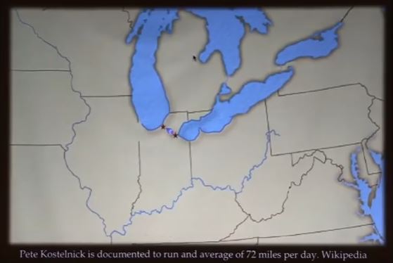
Some time after the Walk the Walk
challenge was made (2013), the Heartland Model's "narrow pass" idea was
revised. The revision led to a shortening of the proposed Desolation-Bountiful
line.
Recall the Narrow Pass noted on the map from Volume Two of Wayne
May's 2004 (2006) THIS LAND series (shown previous)? Near the end of an exciting 2017
presentation, Wayne redefined "the narrow pass" to be a 70 to 80 mile wide
isthmus between ancient fens of Lake Erie, called the "Great Black Swamp",
and the long ago shore of Lake Michigan (both featured in the slide above).
According to the new idea, the 1.5 day journey spanned the 70 to 80 mile
wide isthmus - the newly alleged "narrow pass".
Ok, so the distance is now somewhat less ridiculous, but where heartlanders
previously needed a fast ride, they now need at least a
professional runner to validate their model. The situation is eerily like
the dilemma that besets the Tehuantepec hypothesis.
In order to validate a
1.5 day journey across the wide, lateral Mesoamerican isthmus,
proponents are in want of an incredible runner, rower, or rider. Never mind that
the scriptural word מהלך
(e.g. Yonah 3:3-4), translated "journey"
in Jonah 3:3-4, comes from the word for
"walk";
let heartlanders and Tehuantepec-ers pick their athlete to put their Desolation – Bountiful lines to the test.
Prove it! If you can't Walk the Walk, you better Run, Row, or Ride.
But who are we kidding? Even with ancient shores and fenlands
taken into account, the revised Heartland Model isthmus is still far too wide to
pass as a "narrow passage".
The Book of Mormon "narrow pass" is also called
"the narrow passage". (Mormon 2:29;
3:5) The word translated
"passage" in 2 Nephi 20:29 (Isaiah 10:29) is "mabarah"
(מעברה).
The same word is translated "pass" or "ford". This "passage"
mentioned in 2 Nephi 20:29
is a
narrow defile
in the mountainous country north of Jerusalem. It's tiny
compared to the breadth of Israel's coast. To suggest
that "the narrow passage" could be as wide, or wider than say,
the distance from the western sea (Mediterranean) to the Jordan, or
to either of the seas (lakes) on the east (a distance of about
40 miles), is absurd!
Yes, "narrow" is relative, even geographically speaking (1 Nephi 21:29)
- that's not the issue. The point is, "the narrow
pass" or "narrow passage" was probably comparable in width to
other geographic passages mentioned in scripture.
Similar uses of the word "pass" in the Book of Mormon, describe something far narrower than the
breadth of the Heartland model's latest "narrow pass".
(Mosiah 22:6,
Alma 49:21-22)
Here is the link to Wayne
May's exciting, but here and there incorrect, 2017 presentation:
"Book of Mormon Geography in North America".
By way of contrast, the Batavia Moraine of western NY
(too small to show on the map above)
definitely qualifies as a "narrow pass". The moraine is truly "a small neck of land"
(Alma 22:32)
passing between the marshy remnants of an ancient inland
"sea, on the west and on the east".
(Alma 50:34)
In other words, a sea (singular) was proximal to the narrow pass (Mormon 3:5-8),
flanking it on either side. The isthmus was so small that it was perceived to pass through a single body of water
(ancient Lake Tonawanda near Cumorah).
In an effort to fix their model, heartlanders imitate
another desperate Mesoamericanist idea:
Isthmus of Tehuantepec
"narrow neck" proponents have concluded that the entire Desolation –
Bountiful line spanned the isthmus from sea to sea. Scripture doesn't
say this. The Tehuantepec Isthmus is arguably 119 miles wide (minimum).
Heartlanders similarly think to span the
Desolation-Bountiful line across the isthmus they have recently claimed is "the narrow pass". But there is a problem
with this idea: The entrance to the narrow pass was a
"point"
(Alma 52:9) with water on the west and east of it.
(Alma 50:34) This geographic
"point"
(passage
entrance) was near the Desolation – Bountiful line. The "line" was not
within the "point"!
The divided "narrow neck of land"
(Ether 10:20), near Hagoth's
launch site, was also "by" the Desolation - Bountiful line, the western
terminus of which was "the west sea"
(Alma 22:32-33;
63:5). Hagoth
did not launch his "exceedingly large ship" from an isthmus. He launched it "by
the narrow neck" into "the west sea".
Wayne, on the other hand, now toys with the idea of not placing the divided neck
by the west sea. See the slide above.
But the descriptions of the Book of
Mormon's narrow neck are as follows:
(1) "...the west sea by the narrow neck which led into the land northward."
(Alma 63:5)
(2) "...the narrow neck of land, by the place where the sea divides the
land." (Ether 10:20)
In the slide above, you will note that more than one isthmus connects to
northern territory. In fact, there is more than one divided isthmus that
leads to land northward. So being divided by a sea, and leading to more
northern land, does not uniquely specify an isthmus in the Great Lakes
region. Notice, however, that both (1) and (2) tell of "the narrow neck". The use of
the definite article "the", and not a narrow neck,
suggests that "the narrow neck" described in (1) and (2) is the same narrow neck
unique
to a more local, limited geography - smaller than the scope of Wayne's slide.
The presence of so
many necks of land (even divided ones) throughout the Great Lakes region,
hints that the principle lands of the Book of Mormon near Cumorah, with "the narrow neck of land", and "the
narrow pass", are more localized. They are coastal - like the land of
Israel (the
Northern and Southern Kingdoms); narrower in scope than the region displayed in the
map above.
The other Hebrew word translated
"journey", דרך, derives from
"tread".
Running (as in a marathon) is not suggested. Note the context in
Genesis 30:36
(Bereshit 30:36)
and
Numbers 11:31
(Bemidbar 11:31).
Above, Wayne confuses the Desolation – Bountiful line with the fortified line between Bountiful on the north, and Zarahemla on the south.
(Helaman 4:5-8)
These are not the same geographic lines. What is more, neither line resides within a neck, or isthmus. The 1.5 day line (Desolation – Bountiful line) was at the northern end of Bountiful. The one day fortified line was at the southern end of Bountiful.
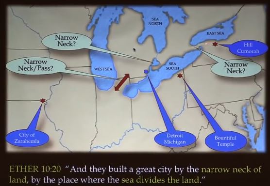
Above is a recent rearrangement of the Heartland Model. Curiously, Bountiful
does not show up in the isthmus between the "GREAT BLACK SWAMP" and ancient
Lake Michigan (the alleged "WEST SEA"). But the west sea was at the western
end of Bountiful!
(Alma 22:33)
What is more, Bountiful was north of Zarahemla.
(Alma 22:27-34;
50:8-11,
Helaman 1:23;
4:5-8,
3 Nephi 3:23-24)
You will recall that Mesoamericanist minded Ed Goble tried to fix things by
twisting compass directions. He didn't succeed at this - not convincingly.
Ancient Hebrews simply
looked to the heavens to determine directions.
The lands of Bountiful, Zarahemla and Nephi should all situate inland from
the coast of
"the west sea".
(Alma 22:23-34;
50:8-11;
53:8,
22,
Helaman 4:5-8)
Note also the attempt, in the above map, to introduce a "narrow strip of
wilderness" into the Heartland Model. The problem is, the "narrow strip of
wilderness" ran between "the east sea" and "the west sea".
(Alma 50:8,
11,
13;
22:27-34)
In scripture, "east sea" and "west sea" are names of bodies of water.
(Ezekiel 47:18,
YehezqEl 47:18)
There is no capitalization in Hebrew.
The terms
"sea east" ("sea, on the east", Alma 22:27),
"sea west", "sea north", and "sea south" are relative expressions; as are
"land northward" and "land southward". They depend on a frame of reference.
They are not
names.
(Helaman 3:8)
Similar expressions exist in the Bible.
(Joshua 23:4)
What Wayne has recently promoted as "a place to start", is actually where the Heartland Model has, after many years, wound up. It’s a dismaying mass of contradictions
- but hey, at least it includes scriptural Cumorah!
In the final analysis, Ed's creation and denunciation of the Heartland Model may be
seen to serve a higher purpose. In the hands of Rod Meldrum, Wayne
May, and others, the model has become a kind of serpent on a pole, leading
thousands of scripturally unstudied Church members to look closer to Cumorah,
away from
more false geographic traditions. But there is a
cautionary tale to the serpent on the pole. In ancient times, when the people were found making too much of the manmade
thing, it was destroyed!
(2 Kings 18:4-5)
Can a Land "called the land of desolation" in Illinois, be
Reconciled Without Far-flung Geography?
The Levi Hancock Zion's Camp record includes a description of events
"after entering the wide prairies ... On the way to the Illinois River".
Near this time Joseph Smith dictated a letter to his wife Emma
(4 June 1834).
The letter bears the Prophet's name. it
was doubtless reviewed by Joseph before it was sent. The letter
is more confidently attributable to Joseph Smith, than Levi Hancock's
account of what Joseph supposedly said to Sylvester Smith about an Illinois
land "called the land of desolation".
Regarding the progress of Zion’s Camp, the letter to Emma reads:
"The whole of our journey, in the midst of so large a company of social honest
men and sincere men, wandering over the plains of the Nephites, recounting
[p. 57] occasionaly
the history of the Book of Mormon, roving over the mounds of that once
beloved people of the Lord, picking up their skulls & their bones, as a
proof of its divine authenticity …"
In his letter, Joseph not only identifies Nephites as mound builders, he
positively identifies certain plains (prairies of Illinois) as
"the plains of the Nephites".
Question: If the prairies of Illinois coincide with the Book of Mormon
land of Desolation, why didn’t Joseph refer to these as the plains of the Jaredites
- i.e. wandering over the plains of the Jaredites and Nephites ...?
The Jaredite land of Desolation and plains of "Heshlon" and "Agosh" in the "north country", were in the vicinity of large bodies of
water.
(Alma 22:30-32;
50:29,
Ether 1:1;
13:28-29;
14:11-16,
26;
15:8)
Nephite plains mentioned in the
Book of Mormon, were near at least one eastern body of water or "sea".
(Alma 50:13-15;
51:26;
52:20-22;
62:18-19)
The "plains of the Nephites" identified by Joseph in his letter to Emma, do not match the Nephite plains describe in the
Book of Mormon. Why?
Possibly the Illinois prairies came to be inhabited by Nephites
at a time when their nation spread northward and southward into other lands;
away
from their relatively small principal lands near the coast of "the west
sea". The "west sea" was not far from
other bodies of
water, one of which was called
"the east sea".
Scripture hints that "the east sea" of the Book
of Mormon, like the Bible's "east sea",
was a lake.
(Joel 2:20)
In 1832, W. W. Phelps published his opinion about the "extensive prairies, where the Jaredites
filled the measure of their time." Brother Phelps associated these "extensive
plains" (the Great Plains of America) with "the land of Desolation, as it is called in the book of
Mormon", and wrote of both the Jaredites and the Nephites inhabiting "this choice land".
("THE FAR WEST", Evening and Morning Star, Vol. I, September, 1832. No. 4, pg. 37)
Did Joseph think W. W. Phelps was correct in identifying the Great Plains as the Jaredite
land of Desolation, or did Joseph obtain a different understanding by
revelation? Is there another explanation for why some part, or all of the Illinois prairies
might be "called the land of desolation", one which also explains why Joseph did not refer to the
Illinois prairies as the plains of the Jaredites, in his letter to Emma?
Brother Phelps' published opinion, equating Desolation with the Great
Plains, could have been a subject of
discussion, perhaps even debate between Joseph and Sylvester Smith, during their trek through
Illinois. Assuming Brother Hancock was present when Joseph addressed
Sylvester Smith, we have the following account, and secondhand statement
attributed to Joseph Smith:
"In the morning
many went to see the big mound about a mile below the crossing.
I did
not go on it but saw some bones that were brought back with a broken
arrow. They were laid down by our camp. Joseph Smith addressing himself
to Sylvester Smith and said, “This is what I told you and now I want to
tell you that you may know what I meant. This land was called the land
of desolation …” These words he said as the camp was moving off the mounds
as near as I could learn he had told them something about the mound
..."
In the Book of Mormon, a land was called "desolate" because of
"the greatness of the destruction of the people who had before inhabited the land …"
(Helaman 3:6,
2 Nephi 16:11; see also
Jeremiah 32:43) The Nephites called a northern Jaredite land
"Desolation" because "it came into the land which had been peopled and been destroyed …"
(Alma 22:30)
The Jaredites had been warned that "their bones should become as heaps of earth upon the face of the land ..."
(Ether 11:6)
Similarly, the land of Ammonihah, where many of the cult of Nehor were destroyed in Nephite times, was called
"Desolation of Nehors".
(Alma 16:11) The dead of that land were heaped up in mounds upon the earth. The Nephites
avoided the putrid area "for many years".
We should consider that there have been, and will be "many desolations"
(LDS Doctrine and Covenants 45:33,
Isaiah 61:4;
62:4).
See W. W. Phelps' LAND OF DESOLATION for a lists of Hebrew words translated "desolation" or "desolate" in the Book of Mormon.
At their civilization's bitter end, "the Nephites who had escaped into the country southward, were hunted by the Lamanites, until they were all destroyed."
(Mormon 8:2)
What if the "south countries" of the Book of Mormon are one and the same as
"the south countries" named by the Lord in the Doctrine and Covenants?
These are lands southward from Amherst Ohio, that is, southward from the "west
sea" (Lake Erie).
Amherst Ohio is where the Prophet Joseph Smith received the word
of the Lord mentioning "the south countries". Much of the heartland of the United States
may then
correspond to the Book of Mormon "south county" or "south countries".
(LDS Doctrine and Covenants 75:8,
17
Mormon 6:15,
8:2)
Though the wide open heartland of America is not where the principal lands of the
Book of Mormon reside, certain
Nephites may have made a last stand there.
This land
then became a land of desolation of Nephites,
different from the land of "Desolation of Nehors",
and the land of "Desolation" of Jaredites
named in the Book of Mormon.
The
1834 Levi Hancock account
attributes to the Prophet the following remarks: "This land [coinciding with the Illinois plains of the Nephites] was called the land of desolation and Onedages
was the King and a good man was he." The account continues to quote Joseph Smith as saying, "There in that mound did he bury his dead and did not dig holes as the people do now, but they brought their dirt and covered them until you see they have raised it to be about one hundred feet high. The last man buried was
Zelf or Telf.
[צלף,
or else a masculine version of
זלעפה,
meaning “Raging Heat”]
He was a white Lamanite who fought with the people of Onedagus
for freedom ..." Brother Hancock adds, "These words he [the Prophet Joseph] said as the camp was moving off the mounds
as near as I could learn he had told them something about the mound and got them to go and see it for themselves.
I then remembered what he had said a few days before
while passing many mounds on our way …"
It should be pointed out that King Onedages is not a Book of Mormon character.
Unlike the name "Onidah" (Oneida), Onondaga
(variously spelled)
doesn't appear in the Book of Mormon. It is possible that Onedages reigned after the destruction of the Nephite nation; and that
the portion of the
"plains of the Nephites" that he came to preside over were
ironically
"called the land of desolation" not because Jaredites were destroyed there, but because of the
more recent desolation of the Nephites
in that land.
(Mormon 6:15,
8:2)
Joseph Smith placed the arrival of the Jaredites in the "lake country of
America" (region of Lake Ontario) and apparently agreed with
Josiah Priest
about the eventual, southward migration of ancient peoples from the Great
Lakes region into Mexico and Central America.
See "Traits of the Mosiac History, Found among the Azteca Nations",
Joseph Smith's editorial
(signed "ED") on a chapter from Josiah Priest's American Antiquities,
published in the June 15, 1842 edition of the Times and Seasons
newspaper.
The historical writings of Mariano Veytia touch on the long southward migration of ancient northern American people into Central America. Veytia's account mentions the people's propensity for naming newly settled cities after cities from which they had departed. (Mariano Vetia,
Ancient America Rediscovered, First English Translation of Veytia's
Historia Antigua de Mexico, Translated by Ronda Cunningham, compiled by Donald W. Hemingway and David W. Hemingway, Bonneville Books, 2000, pg. 50)
If the Illinois spot "called the land of desolation", is
not the land of "Desolation" mentioned in the Book of Mormon, but bears a name appropriately (perhaps
ironically) repeated by later
people, should we not also call into question the primacy of a Manti in
Missouri, and a Zarahemla in Iowa, especially since these alleged
ancient sites are not clearly established by scripture?
Of the several
Zelph accounts,
only Levi Hancock's journal mentions "the land of desolation" encountered
during the trek of Zion's Camp through the heartland.
Even so, Joseph could have identified some part, or all of "the plains of the Nephites" in
Illinois as a land "called the land of desolation". This does not mean
that far-flung geographies like
W. W. Phelps’, or
Patriarch McBride’s are
required to account for King Onedages' land of desolation. The Illinois land
of desolationn, in all likelyhood, is not the Jaredite land of Desolation.
Remember, the Jaredite land of Desolation, north of Bountiful, was near the "west sea", and other
"large bodies of water" in "the land which was northward".
(Alma 22:31-32;
50:29,
33-34)
In fact, a more distant land northward, described as "desolate", was
bordered in each of the cardinal directions by bodies of water called seas.
(Helaman 3:3-6;
8)
Above: A more distant land northward (northwest of Cumorah), bordered in each of
the cardinal directions by inland seas, as described in
Helaman 3:8.
Hebrew east (relating to sunrise) is noted. The expression "face of the whole earth" in
Helaman 3:8, is a biblical expression
referring to the full extent of a local land or region.
Consider Genesis 41:56,
Exodus 10:15.
See also Ether 13:17,
25-26,
31.
Though Levi Hancock's account does not tell us the geographic extent of Onedages'
"land of desolation",
other Zelph accounts indicate that "Onandagus"
was known as far west as the Rocky Mountains - no mention of the more
distant
Sierra Madre,
and the Pacific Coast. This challenges the notion that "the land of desolation" over which "Onedages
was the King", reached far and wide into southern Mexico (Central America).
Had his rule and renown extended that far, it certainly would have been
noteworthy! Keep in mind Brother Hancock did not quote Joseph as saying that Onedages
was the King of only a portion of the land of desolation. Rather, Levi Hancock
recorded the Prophet as saying in Illinois, "This land was called the land of desolation and Onedages
was the King and a good man was he."
East to West Renown of Onandagus (based on
Zelph accounts).
The point is, there is no mention of his domain, or his fame extending to the Isthmus of Tehuantepec (Mexico).
Mounds of Human Skeletons Found near Lake Erie and Lake Ontario
"… The purpose of the mounds of New York, so far as can be determined, seem uniformly to have been those of sepulture. They generally occur upon commanding or remarkable positions. Most of them have been excavated, under impulse of an idle curiosity, or have had their contents scattered by
“money-diggers,” a ghostly race, of which, singularly enough, even at this day, representatives may be found in almost every village. I was fortunate enough to discover one upon Tonawanda Island, in Niagara River, which had escaped their midnight attentions. It was originally about fifteen feet in height. At the base appeared to have been a circle of stones, perhaps ten feet in diameter, within which were several small heaps of bones, each comprising three or four skeletons. The bones are of individuals of all ages, and had evidently been deposited after the removal of the flesh. Traces of fire were to be discovered upon the stones. Some chippings of flint and broken arrow-points, as also some fragments of deers' horns, which appeared to have been worked into form, were found among the bones. The skulls had been crushed by the superincumbent earth.
The mounds which formerly existed in Erie, Genesee, Monroe, Livingston, St.
Lawrence, Oswego, Chenango, and Delaware counties, all appear to have
contained human bones, in greater or less quantities, deposited
promiscuously, and embracing the skeletons of individuals of all ages and
both sexes. ...They were sometimes heaped together so as to constitute
mounds; at others placed in pits or trenches dug in the earth ... or
deposited in caverns, either promiscuously or with regularity."
(E. G. Squier,
ABORIGINAL MONUMENTS OF THE STATE OF NEW YORK, Originally published in the Smithsonian Contributions to Knowledge, Volume 2, 1849, Ch. IV,
"MOUNDS, BONE-HEAPS, ETC.", pg. 67)
"In Greene township, about two miles below the village, was formerly a mound of some interest … An examination of the mound was made in 1829 by excavation. Great numbers of human bones were found; and beneath them, at a great depth, others were found which evidently had been burned, No conjecture could be formed of the number of bodies deposited here. The skeletons were found lying without order, and so much decayed as to crumble on exposure. At one point in the mound a large number, of perhaps two hundred, arrow-heads were discovered, collected in a heap. .. another pile of sixty or more, was found in another place, in the same mound; also a silver band or ring, about two inches in diameter, wide but thin, and with what appeared to be the remains of a reed pipe. A number
of stone gouges or chisels, of different shapes, and a piece of mica, cut in the form of a heart, the border much decayed and the laminae separated, were also discovered.
It may be mentioned here, that the character of the lower deposit, and also some of the relics, coincide with some of those found in the mounds of Mississippi Valley. The ancient mound-builders often burned their dead. The upper and principal collection of bones had probably a comparatively late date, as is shown by the silver bracelet, which, it is presumed, although not so expressly stated, was found with this deposit."
(E. G. Squier,
ABORIGINAL MONUMENTS OF THE STATE OF NEW YORK, Volume 2, 1849,
"CHENANGO COUNTY", pg. 34; see also
Joseph Smith – History 1:56)
"In cultivating the area, many fragments of human bones, some of them burned, have been observed, - suggesting the possibility that the ancient village was destroyed by enemies, and that these are the bones of its occupants who fell in defense of their kindred, and were burned in the fires which consumed their lodges."
(E. G. Squier,
ABORIGINAL MONUMENTS OF THE STATE OF NEW YORK, Volume 2, 1849,
"JEFFERSON COUNTY – EARTH-WORKS, ETC.", pg. 20)
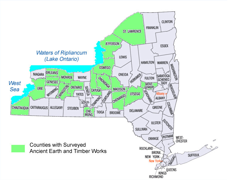
ABORIGINAL MONUMENTS OF THE STATE OF NEW YORK Surveyed by E. G. Squier
LDS Scripture specifically identifies native people living in the
western wilderness near Lake Erie, as "Lamanites" - descendants of
Book of Mormon
people.
(LDS Doctrine and Covenants 32:1-2)
In the early days of the Church, missionaries were sent to
these natives, "remnants of the house of Joseph ... residing in the west", to give them
glad tidings of the Book of Mormon. (History of the Church 1:118-120)
Ed Goble's response to this article
Vincent Coon וינסנט
כון
© Copyright 2019
|